
2021-09: French Island
2021-07: Mitchell Grass
Rangeland
2021-06: Boyagin and
Ridgefield
2021-04: Warra
2021-03: Howard Springs
2020-11: Calperum
2020-10: Ashley Dene
2020-09: Alice Mulga and
Ti Tree East
2020-08: Wombat Forest
2020-07: Kopuatai Bog
2020-05: Gingin
![]() = external link, new window
= external link, new window
Our site feature this month has us travelling out to part of Australia's wild west – the wheat belt region of Western Australia. This month is a paired site feature, including the Boyagin Wandoo Woodland site - both an OzFlux and TERN  Ecosystem Processes monitoring SuperSite - and the nearby Ridgefield Farm OzFlux site.
Boyagin was established at the end of 2017 in a patch of remnant Eucalyptus wandoo woodland within the Boyagin Rock Nature Reserve , about 175 km southeast of Perth. This ecosystem type was once widespread in the wheat belt region before land clearing for agriculture. Ridgefield is a paired agricultural site located at the University of Western Australia (UWA) Ridgefield Future Farm , and was established in 2015. The Ridgefield farm is used for rotation cropping of primarily wheat and canola, as well as sheep grazing. Both sites are managed by Professor Jason Beringer , with help from Dr Caitlin Moore and Mr Tim Lardner at UWA.
A perfect pair of towers for native and managed ecosystem monitoring
The Boyagin and Ridgefield sites are located approximately 4 km apart, so they provide an ideal pair of towers to help understand differences in landscape dynamics in the WA wheat belt. The WA wheat belt supports $2.7b from cropping and grazing systems, but also contains pockets of biologically significant landscapes, including the Boyagin site. The overall aim of these two sites is to quantify carbon, water and energy flux differences between the two different land use types, and determine how past, current and future climate variability is likely to impact on these fluxes.
You can see the real time fluxes from the Boyagin and Ridgefield sites thanks to the Land Ecosystem Atmosphere Program (LEAP) at UWA.
The two monitoring sites also form part of Australia's emerging Critical Zone Observatory (CZO), which has been funded by the Australian Research Council's Large Infrastructure, Equipment and Facilities scheme (ARC LIEF) to create a new network of five core and five satellite monitoring sites in five states, sampling a diversity of Australia's geologies, biomes, land uses and climates.
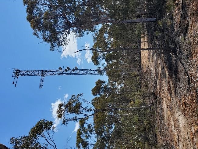
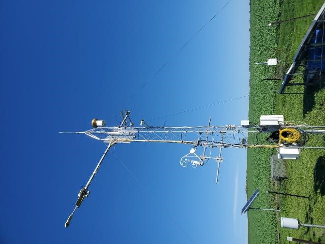
The Boyagin flux tower (left, credit: Caitlin Moore) and the Ridgefield flux tower (right, credit: Caitlin Moore) in the WA wheat belt region.
Boyagin Nature Reserve – a place of cultural significance and unique biodiversity
Located in the Boyagin Rock Nature Reserve, the Boyagin site is near (but outside of the tower footprint) a large granite outcrop called Boyagin Rock. This rock, also known as Boodjin, is a place of immense spiritual and cultural significance to the traditional custodians of the south-west WA lands – the Noongar People.
In the Noongar language, the rock gets its name from the term "Boya", meaning rock or hard stone, and "djinning", meaning looking or seeing – so it is the rock that sees .
In addition to its cultural significance, the Boyagin Rock Nature Reserve is home to a community of rare plants and animals, many of which are endemic to the southwest region of WA. Included in this is the endangered (and incredibly cute) Numbat . TERN's wildlife acoustic sensing and camera traps at Boyagin are contributing towards monitoring the rare wildlife that lives in the reserve. And although it was missed by the TERN camera trap, numbats have been spotted near the flux tower – the video evidence from Tim Lardner is below!
Numbat at TERN Boyagin Wandoo Woodland SuperSite from TERN Australia .
'It's always a treat to visit this site. There is always something new to see there and it keeps surprising me. I love the way that the tree trunks change colour with the seasons and the diversity of the tiny plants that grow low on the ground. Every so often we are lucky enough to spot a local mammal, and it amazes me that, even though the woodland is not fenced off from introduced predators, our camera traps have only ever captured native species like brush tailed possums, Western grey kangaroos, chuditch, and quenda.' - Mr. Tim Lardner
Improving ecosystem stress detection at Boyagin and Ridgefield
A big issue facing the wheat belt region is the projection of a hotter and drier future climate. Boyagin and Ridgefield typically experience mean maximum daily temperatures from 15.3 °C in winter to 31.9 °C in summer. However, temperatures have reached as high as the mid-40 °C range in the nearby town of Pingelly, WA . Dr. Caitlin Moore from UWA says that the Boyagin and Ridgefield sites tell an interesting story about ecosystem stress and how the two ecosystems manage it.
'Data from the last three years of measurement at the sites show the energy balance at both sites is dominated by sensible heat flux, which is reflective of the annual dryness of the wheat belt region. It is only during the winter months that sensible and latent heat flux converge.
Fortunately, this is when the winter wheat and canola cropping systems are planted. However, changes in the timing and duration of winter rainfall events increases the likelihood of water related stress in both ecosystems. Likewise, if summer temperatures rise this will increase the likelihood of heat related stress, particularly for Boyagin and for Ridgefield when under a grazing rotation.' - Dr. Caitlin Moore
To quantify the response of vegetation stress faster in these critical ecosystems, an exciting new biodiversity monitoring capability for Western Australia has enabled the installation of state-of-the-art monitoring infrastructure.
Solar-induced chlorophyll fluorescence (SIF) sensors have been installed to measure the signal emitted from leaves during photosynthesis, which can be linked with plant stress.
'Our aim with this new equipment is to test how well SIF can be linked with ecosystem productivity in Australia and whether it provides a better indication of ecosystem stress than other vegetation indices that rely on changes in greenness to indicate stress.' – Dr. Caitlin Moore
The new project and its equipment has been made possible thanks to co-investment in NCRIS-enabled TERN from the Government of Western Australia and co-contributions from The University of Western Australia (UWA), Edith Cowan University (ECU), CSIRO, and the WA Department of Biodiversity, Conservation and Attractions (DBCA).
With an eye to future expansion, the capability will also serve as a pilot study for an Australia-wide biodiversity monitoring framework that could be rolled out nationally by TERN.
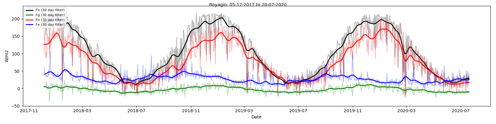

The Surface Energy Balance timeseries for Boyagin (top) and Ridgefield (bottom). Variables include net radiation/energy (Fn), soil heat flux (Fg), sensible heat flux (Fn) and latent heat flux (Fe). Data are presented as daily averages with a 30-day rolling mean.
Supported by
A contributor to

Partner organisations